5 BEST NEW ZEALAND HIKES IN THE SOUTH ISLAND
- Rach Stewart

- Jul 26, 2021
- 7 min read
Updated: Sep 25, 2025
Carrying on from my 5 Best New Zealand Hikes in the North Island blog, I've thought long and hard about the trails I have done in the South island of New Zealand and the ones that stand out and deserve to be in a Top 5 list.

I often get asked where the best New Zealand photography locations are and a fair amount of the time those absolutely epic views involve some degree of hiking.
New Zealand Day Hikes have a bit of everything. They can be just a 45 minute trek up a small mountain, or a 10 hour one way trip across an active volcano field .. you can take your pick! There is something for everyone and you don't have to be extremely fit to complete the easier ones.
In this blog you will find my 5 Best New Zealand Hikes in the South Island for photography, where they are located, their difficulty level, elevation gain, tips and photography advice.
Before setting out on the Best Hikes in the South Island of New Zealand, it’s worth learning about what is eSIM, a convenient way to stay connected without relying on physical SIM cards while you're visiting here.
Let's begin near the top of the South Island then work our way into Fiordland, Wanaka and Aoraki Mount Cook National Park.

TOP 5 BEST NEW ZEALAND HIKES IN THE SOUTH ISLAND
1. MOUNT STOKES MARLBOROUGH

When I first did the Mount Stokes hike back in 2016, it wasn't a hugely popular New Zealand Day walk and the photos I took received a lot of interest on Instagram and Facebook. People were saying it looks like Roys Peak, or better than Roys Peak! And where was it, and how did I get there? I kept fairly quiet about it as I didn't want the place to be overrun and damaged, but I do think everyone should be able to experience such an amazing view!

To experience one of the best views over the Marlborough Sounds and reach the summit of Mt Stokes at 1206 metres, you will need to be prepared for a steady climb up hill for most of the way and a 4-5 hour return journey.
The road to get to the track is a bit of an adventure with it being gravel and a lot of twists and turns. You will have to endure this for 41 kilometres until you see the carpark and where the track begins. It is worth it trust me!

We chose to do this hike for sunrise as it offers beautiful light and the chance of fog/low cloud over the sounds .. which is exactly the conditions we got. It was truly beautiful and I am so happy we opted for the early wake up of 2am and ascending in the dark. You could also opt to do the track during the day, camp up top, and do both sunset and sunrise.
Location: Kenepuru Road (Queen Charlotte Drive turn off at Linkwater) Marlborough
Distance: 7km return
Time: 4-5 hours return
Elevation gain: 655 metres
Difficulty: Advanced
Hut booking: N/A
Dogs: Yes - permit required through DOC

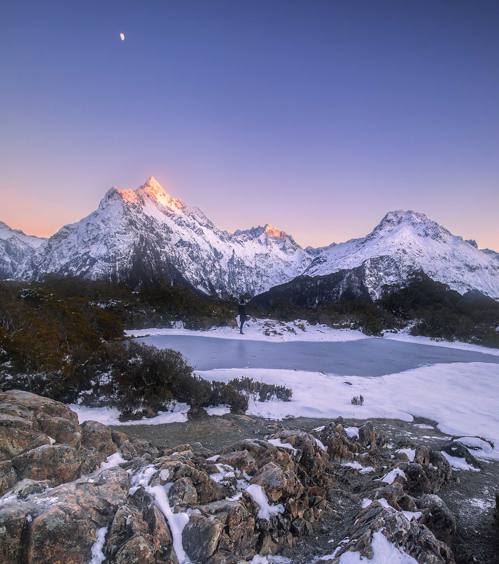
2. LAKE MARIAN TRACK FIORDLAND

Now this New Zealand Day hike is one that left me in absolute awe when I arrived at the finish point. Tucked away high up in the mountains lies the incredibly stunning alpine lake, Lake Marian. Surrounded by towering mountains, you would think that it would have to take a lot of effort to get here, but it doesn't! The effort / reward ratio is one of the best ever.
The first 30 minutes of the Lake Marian track is a well established path which leads you to the Marian falls boardwalk. There are definitely some amazing photos to be had here with ice blue glacial waterfalls and mossy green rocks making a beautiful combo.

After the Marian falls the track becomes fairly rugged with tree roots, some mud and rocks to navigate through, but it is a short hike so not a huge amount of effort is required. After about an hour you will arrive at the hanging valley and the incredible Lake Marian .. take in the views and spend some good time here! There is plenty of foreshore around the lake to photos, some navigation is required around the rocks however, but nothing too difficult.

Please be wary around the lake during winter and spring as the avalanche risk is high (I saw an avalanche while there).
Location: Turn off Milford Road onto Hollyford Road, then in 1km you will reach the Lake Marian carpark
Distance: 3.1km return
Time: 3 hours return
Elevation gain: 300 metres
Difficulty: Intermediate
Hut booking: N/A
Dogs: No
Check out more info in my Hiking the Lake Marian Track Fiordland New Zealand Guide.


3. KEY SUMMIT TRACK FIORDLAND

The Key Summit track is a must do if you're visiting Milford Sound and want to try out a well established New Zealand Day hike to fill in your day. It has been said it is the best day hike you can do in the Fiordland area and I totally agree! The views over Fiordland National Park and both the Hombolt and Darran Mountains are absolutely spectacular. Not only that, there is an alpine tarn waiting for you at the summit where you can capture reflections of the surrounding mountains and scenery on a windless day. Its a win win!

The beginning of the Key Summit track is actually the start to the Routeburn Great Walk from the southern end, so the path is well maintained and nice and wide to walk on. You will experience stunning rainforest, alpine scenery and panoramic mountain views throughout your ascent to the summit.

I chose to do this hike at sunrise during winter in the hope of getting the first light hitting the snowy mountain peaks. What I didn't realise was that the alpine tarn would be frozen and gone were my dreams of mountainous landscapes in all their entirety reflecting in the pond! It was actually freezing (-11 degrees) and the next time I complete this one I'll be doing it in slightly warmer weather with my reflection dreams hopefully coming true.
Location: From the Divide carpark (off the Milford Road), take the Routeburn track, then around an hour in you will see the sign to Key Summit (approx 20 mins after you'll be at the summit).
Distance: 6.8km return
Time: 3 hours return
Elevation gain: 400 metres
Difficulty: Intermediate
Hut booking: N/A
Dogs: No
4. SEALY TARNS TRACK MOUNT COOK

Sealy Tarns Mount Cook ... if you love stairs, you will absolutely love this New Zealand Day Hike!!
The Sealy Tarns are two small alpine lakes which sit flat on the Sealy Range in Mount Cook National Park. The track up to the tarns requires a fair bit of stamina as you climb up to 1300 metres and over 2,200 stairs, but the view is most definitely worth it! If you are lucky you might even get a visit from the cheeky Kea New Zealand's alpine parrot .. be care though, they will probably try and pinch your gear or at least try to break some of it.

The Sealy Tarns track actually forms part of the Mueller Hut hike, and if you were to carry on past the tarns and climb another 600 metres you would arrive at the famous Mueller Hut, one of New Zealand's most popular tramping huts.
Please note: during winter months there are heavy avalanche warnings associated with this track .. always check first.

Location: The track starts on the Kea Point track from White Horse Hill Campground at the end of the Hooker Valley Road in Aoraki Mount Cook. The Sealy Tarns track branches off from the Kea Point track.
Distance: 5.1km return
Time: 3-4 hours return
Elevation gain: 548 metres
Difficulty: Intermediate
Hut booking: If completing the entire Mueller Hut hike, between November and April you must book Mueller Hut prior
Dogs: No
Check out my Photo Guide to Mount Cook South Island NZ for more spots to photograph

5. ROYS PEAK TRACK WANAKA
It's famous, but for a very good reason. The view from the top of the Roys Peak Wanaka track is one of the most impressive in the South Island and I remember my breath being taken away getting lost its beauty.

The Roys Peak track was one of the first hikes I did in the South Island and it set the bar very high for anything else that followed after it. From a landscape photography point of view, the shots that can be created from this trail are absolute bucket list and images I took from here have been some of my most popular New Zealand photos ever.

The 1500 metre steep climb over grassy terrain switches back and forth across the mountain right up until you reach the summit. Before getting to the top, you should definitely stop at 'Selfie Point' where you can get the most famous photo of them all, the Roys Peak selfie!

I have completed the Roys Peak track in summer and in winter twice. We encountered quite a lot of snow for the last third of the climb during winter, but as long as you are careful and have the correct gear (hiking boots with crampons are a big help) you shouldn't have any problems.
The track is closed for lambing from 1 October - 10 November each year.
Location: The Roys Peak track starts at the Roys Peak car park on the Mount Aspiring Road near Wanaka.
Distance: 16km return
Time: 5-6 hours return
Elevation gain: 1,305 metres
Difficulty: Intermediate
Hut booking: N/A
Dogs: No

Check out my full blog on Hiking the Roys Peak Track.

I HOPE YOU ENJOYED READING MY TOP 5 BEST NEW ZEALAND HIKES IN THE SOUTH ISLAND
Be sure to check out my 5 Must Do North Island New Zealand Day Hikes for when you visit the North Island also!

