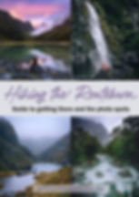
HIKING THE ROUTEBURN TRACK: GUIDE TO GETTING THERE AND THE PHOTO SPOTS
- Rach Stewart
- Feb 28, 2021
- 7 min read
Updated: Oct 15, 2024
The Routeburn Track in Fiordland National Park is considered one of the most rewarding walking tracks in New Zealand. It is among the most popular due to its majestic views and it being one of the shortest of the Great Walks on offer (33km one way). Traversing through both Fiordland and Mt Aspiring National Parks, this walk gives you more than you could wish for when it comes to mountains, lakes, valleys and waterfalls.


I had seen many photos from this special part of Fiordland and because at the time I was not the most experienced overnight tramper, this felt like the perfect one for me. I was lucky enough to be doing it with the team from LOWA footwear and we were all of relative experience.
It was March 2017 and we did the track in 3 days and 2 nights. Although there were some steep climbs in parts, I felt pretty confident the entire way. Don't get me wrong, determination had a big part in getting me past the finish line (we had a lottttt of rain), and I was tired as heck at the end, but I did it without feeling it was too hard.


HIKING THE ROUTEBURN TRACK GUIDE
BEFORE YOU START ....
Routeburn Track Accommodation
You will need to book well in advance your accommodation while on the tramp during New Zealand Great Walk season.
There are no free camping or huts on this walk, and bookings are essential from around the start of November to the end of April. On the off season it is first come first serves basis. For more info on bookings visit the DOC website.

Source: Wikipedia
Of the 4 huts available to book, we stayed at the Lake MacKenzie Hut, and the Routeburn Falls Hut. Both of these had incredible views, and were placed well on the track for our 2 night stay.
Routeburn Hike Starting Points
The Routeburn typically is not a return hike. There are two different trailheads where you can start, one on the Fiordland side (The Divide) and the other on the Queenstown side (Routeburn Shelter). We chose to hike the Routeturn from The Divide end in Fiordland, meaning we were walking facing the view.

Because it is a one way walk you will need to organise transport between the start and the end, whichever route you choose to take. There are a lot of kilometres between the two trailheads (around 325km!) and there is no public transport, but there are a lot of providers offering drop offs and pick ups on both sides. We used Buckley Transport.
Routeburn Tips for packing
Try to keep it as light as you can, without missing the essentials. DOC have an information page outlining what you should take here
Camera gear: in keeping with the above, be selective on which gear and lenses to take! The big heavy 300mm isn't going to feel great after a couple of hours, but if that's your main lens, then make that decision. You can see what camera gear I took below.
Dry bag: be sure to put some/all of your clothing in a dry bag. If the weather is anything like ours was, it's going to be wet for some of the time. Fiordland is famous for it!
Headphones, phone charger/battery pack. Having my music saved me through some of the long stretches.
Headtorch: free your hands from holding a torch or need to go loo in the middle of the night!
Dehydrated meals: these are lightweight and you will be thankful you're not carrying heavy food with you. We chose Back Country Meals. We did notice on the first day that other hikers had fresh packed lunches and since then I've always taken something yummy for the first day!
A celebratory drink never hurt anyone .. if you can spare some space for your fave drink, then do it.
Camera Gear - What I took
Canon 5DMKIV body
Canon 16-35mm lens
Canon 70-200 lens
Nisi Filters (only 6 stop and 0.9nd grad)
Lightweight travelling tripod
Spare battery x 2, charger and spare memory card
Where to stay before and after
I say treat yourself in Queenstown before and after you finish the hike so you've got something to look forward to at the end! I can't tell you how good it was to go out for a nice dinner and stay in a comfy bed after being in the mountains for a few days. We chose The Sherwood Queenstown and it was bliss.

HIKING THE ROUTEBURN TRACK - THE PHOTOS AND THE JOURNEY

Day 1 Routeburn Track: The Divide to Lake Mackenzie
After a 1.5 hour drive from Te Anau to The Divide (be sure to stop at Mirror Lakes (above) along the way!), we arrived at the start of the Routeburn Track. Excited and nervous, the weather had held off and we were ready to go.

On our first day we would hike 12km to Lake Mackenzie with an elevation gain of around 1000m. The track starts through beautiful Silver Beech forest as you steadily climb upwards. Our first stop would be the Lake Howden Hut with the option to take a side trip to Key Summit.

We didn't take this side trip option, but I had previously hiked it in winter so I was happy to have already visited. The views are incredible over the Darran Mountain range and Hollyford Valley, well worth it!
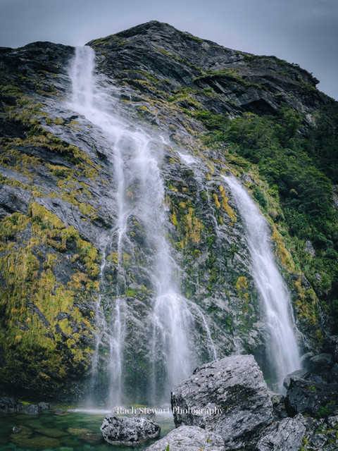
After a quick bite to eat at Howden Hut we carried on to Earland Falls .. what a sight to behold at 174 metres tall! An awesome spot to pull out the camera and admire the pure force of nature.


As we continued towards Lake Mackenzie, the weather started to turn, and rain became our hanger on friend for the rest of the day. In saying this, the mood it created for photos really was spectacular.

They always say Fiordland looks its best in the rain.

We arrived at the Lake Mackenzie Hut around 6 hours after we started, chose our bunk beds and had a well earnt relax by the lake! The hut was very comfortable and well maintained, we were stoked with our home for the night.

About an hour before sunset we headed a little further past the main Lake Mackenzie clearing to a second one further around the corner (signposted track). The sky had started to clear and we chatted and drank some Fireball while we waited for sunset. Boy were we in for a treat.

The following photos are from that sunset, the only sunset with any colour on the hike. Past this point, we never saw the sun again!

As the sun was setting in the opposite direction, we took advantage of the reverse sunset colours and light.


Day 2 Routeburn Track: Lake Mackenzie to Routeburn Falls Hut
Day 2 we woke to rain, and a lot of it. This part of the leg would take us to The Routeburn Falls Hut, some 11.3km away. Although this was not the ideal weather to hike in, we just had to get on with it.
As we made our way above Lake Mackenzie through a series of switch backs, we got to see just how amazing the location was we had been staying in. Towering mountains on every side of us, waterfalls, and the stunning Lake Mackenzie sitting amongst it all.

We continued on through the rain until we reached the Harris Saddle, the highest point on the Routeburn Track. It was hard to stay positive at this point, since we were soaked, tired, and hadn't seen any views through the thick cloud. On a fine day, you would see clear views over the Darran Mountains and the Hollyford. A quick lunch in the shelter and a short walk later, we arrived at Lake Harris.


Just wow .. spirits were back on high!! This place was truly epic. It definitely felt like a Lord of the Rings movie and raw rugged New Zealand was showing its face. Towering waterfalls, mountains, and the feeling that you'd been transported to another world.

A side track option to the summit of Conical Hill is an option (and I've been told well worth it) however it was too dangerous for us on this day in the wet weather.

Re-energised, we continued on down the valley towards the Routeburn Falls Hut. When we arrived we were well beyond impressed.
This 48 bunk building was incredible and sits just under the gigantic Routeburn Falls. On a good day it looks over the Routeburn valley and Humboldt Mountains .. unfortunately it was raining and we didn't see a lot.
We set up our bunks, got into some dry clothing. chatted with others and played cards until it was time for bed.
Day 3 Routeburn Track: Routeburn Falls Hut to Routeburn Shelter - the end
The final day ... we woke to rain (again), but we knew we were so close to the end. The last leg was upon us, and it was only around 8.8km to the finish line.

This part of the track was the easiest out of everything we had experienced, with relatively flat terrain and a well graded track for the most part. The determination was real to get to the end, have some good food and a few beverages to celebrate!

There was not a lot to see for us for the most part due to the weather, but near the end of the trail we crossed some pretty amazing swing bridges over the raging river and the views were spectacular looking up towards the mountains.


Around 3 hours later we reached the end and it was a welcome sight indeed! What an epic little journey for a bunch of newbie overnight hikers.
We drove back to Queenstown, had drinks and amazing food, and witnessed an incredible sunset. What a way to end it all.

If you're thinking of doing the Routeburn Track, I can only tell you TO DO IT! I can't wait to try again in the hope of slightly better weather .. but I came away from the trip with epic views, some great photos and fun memories, and I am more than stoked with that
Check out LOWA's blog post and video on our awesome journey through the Routeburn and if you are looking for boots for your walk my recommendations would be: